Predicting Future Wildfire Intensity: A New Approach to Understanding Future Wildfire Risk
By Telespazio UK…
As wildfires become increasingly frequent and severe across Europe, the insurance industry and emergency planners face a critical challenge: how do we move beyond simply knowing where fires might occur, to how intense could they be?
The Problem
Traditional wildfire risk assessment relies heavily on the Fire Weather Index (FWI) – a well-established metric that tells us about optimal climatological conditions for fires. While useful, FWI only paints half the picture. It’s like knowing the weather is perfect for a storm but not knowing if you should expect light rain or a deluge.
Current long-term projections only focus on these fire weather conditions, but they don’t tell us much about the fires themselves – their intensity, energy output, or potential damage. This gap leaves stakeholders attempting to plan with incomplete information.
A Novel Solution
Our research team at TPZUK, supported by the EOCIS Actionable Information Project, set out to bridge this gap using an innovative approach that combines climate data, earth observations, and machine learning algorithms. The goal? To predict not just where fires will occur, but how intense they’ll be under future climate scenarios.
To achieve this, we assembled a comprehensive dataset spanning multiple sources:
· EURO-CORDEX: High-resolution (~12km) European climate projections from 1970-2098
· CMIP6: Global climate models with lower resolution but broader coverage
· King’s College London FREM Product: Real fire radiative power measurements (2004-2023)
· CORINE Land Cover: Detailed European land use classifications
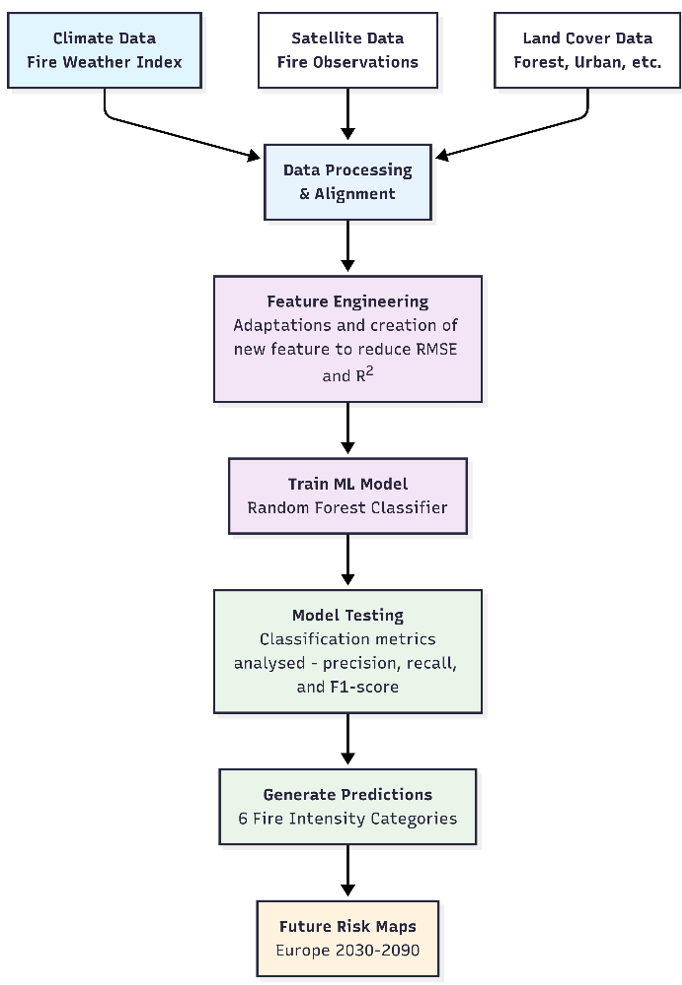
Following some initial analysis the first key finding was identified – resolution matters, which was no real surprise. It was found that the high-resolution CORDEX data (~12 km grid) provided sufficient detail for machine learning training, while coarser global models (~250 km grid) resulted in limited training data, which would significantly impact a machine learning models performance.
The Machine Learning Approach
After testing various approaches, including linear regression models and XGBoost, it was determined a Random Forest Classification model would be used to categorise fire intensity into six classes – from “no fire” to “extreme intensity events.” To do this, the model considers the current fire weather conditions, the recent fire weather patterns (weekly and monthly averages) and local land cover composition to produce its prediction.
Key Steps in ML Approach:
· Data Balancing: We addressed the natural skew in fire data (most days have no fires)
· Feature Engineering: Combined current conditions with historical context
· Cross-Validation: Ensured robust model performance
Results
The initial model achieved 43% accuracy – which is a good first step for a complex prediction challenge. The model performed well when identifying “no fire” (Class 0) conditions and showed moderate success with extreme events (Class 5) (Table 1).
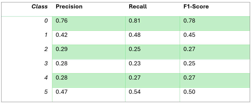
Model Performance:
· Strong at predicting non-fire days (Class 0)
· Moderate success with extreme fire events (Class 5)
· Challenges with intermediate intensity classifications (Classes 2, 3, and 4)
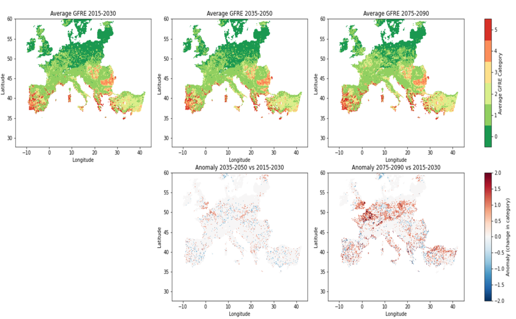
Spatial Predictions:
· Higher intensity fires concentrated in Southern Europe (as expected)
· Some models showed increasing fire intensity toward 2090
· Northern Europe may see modest increases in fire risk
Future Work
While our 43% accuracy represents a good starting point for wildfire intensity prediction, we’ve identified clear paths for enhancement:
· Additional climate variables (soil moisture, drought indices)
· Training with observational datasets (ERA5-Land)
· Integration of consecutive dry day metrics
· Validation against historical fire records
Industry Impact and Actionable Information
This research, developed with support and industry guidance from Willis Towers Watson, addresses real-world needs in:
· Insurance risk modelling: Better understanding of potential fire damage
· Emergency planning: More targeted resource allocation
· Infrastructure protection: Identifying areas needing enhanced fire safety measures
· Climate adaptation: Long-term planning for changing fire regimes
Conclusion
While these techniques are still in development, the early results demonstrate that machine learning can extract meaningful patterns from the complex relationship between climatic conditions, landcover, and fire occurrence.
As extreme weather events become more frequent, tools that provide actionable information about fire intensity – not just occurrence – will become increasingly valuable. This project represents a significant step toward the goal of providing stakeholders with detailed fire risk information needed to make informed decisions about our future.
This research was funded by the EOCIS Actionable Information Project and was supported by Willis Towers Watson who showed great interest in this novel approach. Telespazio UK hopes to continue this work and refine our approach and improve the predictive capabilities.