Long-term Global Mapping of Atmospheric Aerosols from Space
by Dr. Kevin Pearson, Swansea University…
When we hear the word “aerosol” we normally think of something like a can of spray paint or perhaps a scent bottle. Rather than the containers, however, “aerosol” really describes the fine spray of particles or droplets that these dispense and that remain suspended in the air. Suspended aerosols can be injected into the stratosphere as high as 25 km above the Earth’s surface, by volcanoes. In the lower 10 km of the atmosphere, aerosols arise from natural sources such as sea spray and desert dust, and from human sources such as industry and land-clearance burning.
Aerosols have a complex mixture of interactions with the chemistry of the Earth’s atmosphere and with the balance of energy in the climate. Overall, they provide a small cooling contribution to the Earth as they tend to scatter light from the sun back out into space. The size of this effect is quite uncertain, and this is one of the leading factors that limits our ability to predict the speed of future global warming. So, it is important to know how much aerosol is in the atmosphere, where it is and what it is made of.
A new set of measurements of aerosols covering the entire globe and running from 1995 to the present day has been created for the Earth Observation Climate Information Service (EOCIS) by a team at Swansea University. This uses a series of satellite instruments that were originally designed to make highly-accurate measurements of ocean temperatures: ATSR-2 (1995-2003), AATSR (2002-2012), SLSTR-A (2016-) and SLSTR-B (2018-) and uses an approach developed for the European Space Agency by the Swansea team.
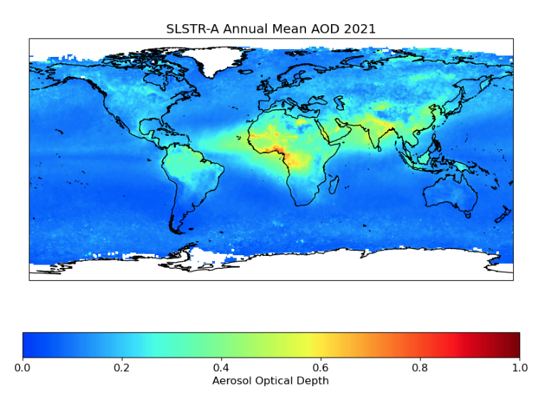
The method identifies the small differences between the light received by the satellites and that which would be expected given the underlying surface. This difference is caused by scattering of light by the aerosols as it makes its way up through the atmosphere and is termed the “optical depth”. An example global map of the aerosol optical depth (AOD) averaged over 2021 is shown below.
Depending on the positions of the sun, earth and satellite, the signal from the scattering aerosols can often be very weak. This makes it particularly difficult to measure over land, where the surface can be brighter than over the ocean and can vary over short distances. It is particularly challenging to try to measure such a small signal against very bright background surfaces like deserts. The ocean, in contrast, has a darker, more uniform surface. As a result, different approaches are used depending on whether the background surface is land or ocean, and much recent effort has been spent tackling the situation over land.
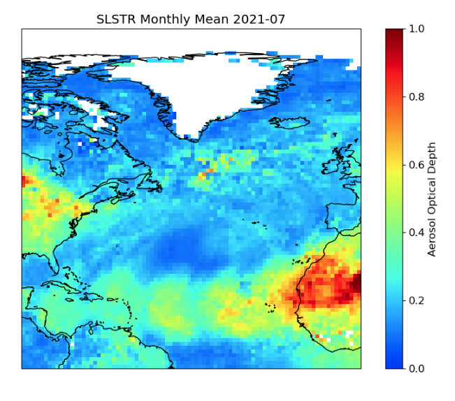
The results have been tested by comparing them to high-accuracy measurements made from the ground at a number of individual locations. This new set of data shows a significant improvement in the measurement of aerosols over land in general and over bright surface regions in particular. The picture below is a map of the average aerosol optical depth from July 2021 for the north Atlantic and shows a large plume of Saharan desert dust. There is a smooth transition here between the amount of aerosol measured over the deserts of north Africa and that measured over the nearby Atlantic ocean, showing how the methods are producing consistent results in these two very different scenarios – a big step forward for aerosol observations!
A full description of the data is available in a new paper in Scientific Data (Pearson, K. et al. 2025, Atmospheric aerosol measurements from the ATSR-SLSTR series of dual-view satellite instruments 1995–2022. Sci Data 12, 410. https://doi.org/10.1038/s41597-025-04694-6). The data can be obtained for free from the Centre for Environmental Data Analysis (http://catalogue.ceda.ac.uk/uuid/17d83baf50a644d89a4fb78ca6cccec1/) and they will be extended by EOCIS until March 2025.