Applications of the EOCIS Land Ice and Sea Ice Datasets
By Jennifer Maddalena, Amy Swiggs, Nicola Bortun, and Kate Briggs…
The Frozen Frontiers
The polar regions are often referred to as Earth’s frontiers of climate change. The ice that blankets these regions is dynamic, constantly growing, shrinking, melting and moving in response to natural cycles and human-influenced climate changes. From impacting the weather we experience, to supporting unique ecosystems and contributing to global sea levels, what happens in the Arctic and Antarctic resonates worldwide.
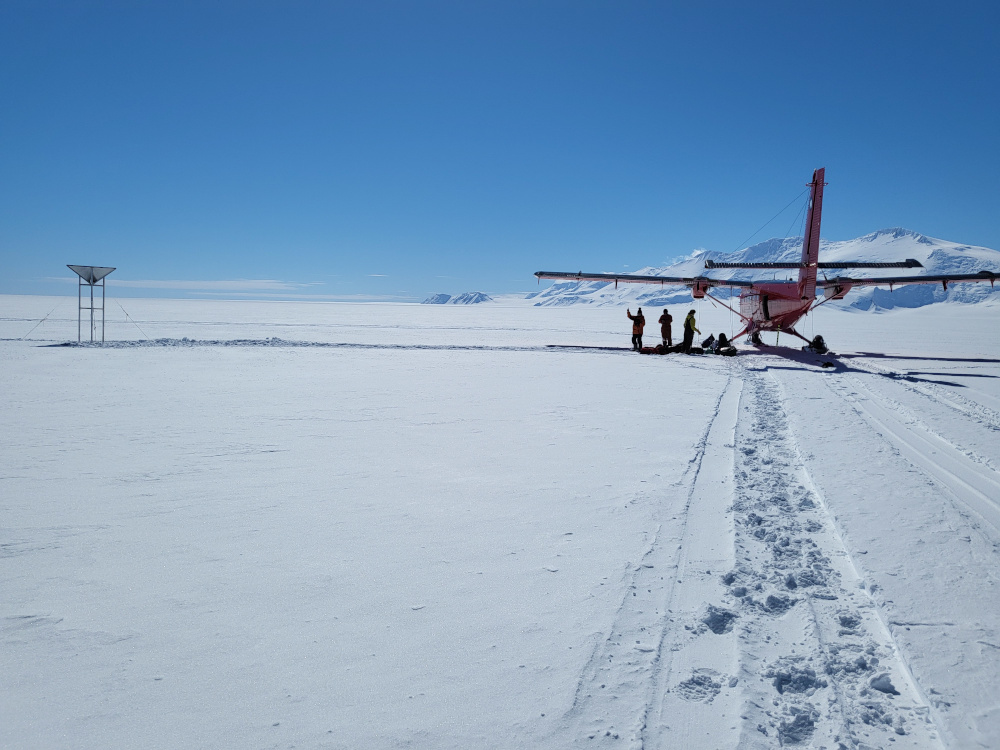
Through collaborative initiatives, such as the UK Earth Observation Climate Information Service (EOCIS), state-of-the-art satellite records are being leveraged to provide crucial updates on the state of land ice and sea ice in the polar regions. These datasets, generated by the UK Centre for Polar Observation and Modelling (CPOM), offer a critical lens into how, when, and why changes are occurring in the Arctic and Antarctic.
The Melting Ice Sheets
Land ice in Greenland and Antarctica is melting into the ocean, directly contributing to global sea level rise and affecting coastlines worldwide. Beyond rising seas, this also alters ocean currents—making them colder and fresher—disrupting the way heat is transported around the planet, affecting global climate patterns. Understanding where and how ice loss occurs is crucial for determining the impact.
The EOCIS land ice dataset provides cutting-edge monitoring of these changes using advanced satellite measurements from the European Space Agency’s (ESA’s) satellite radar altimeters. By tracking ice sheet elevation with improved accuracy and precision, this dataset delivers vital insights into variations in ice sheet height, volume, and mass.
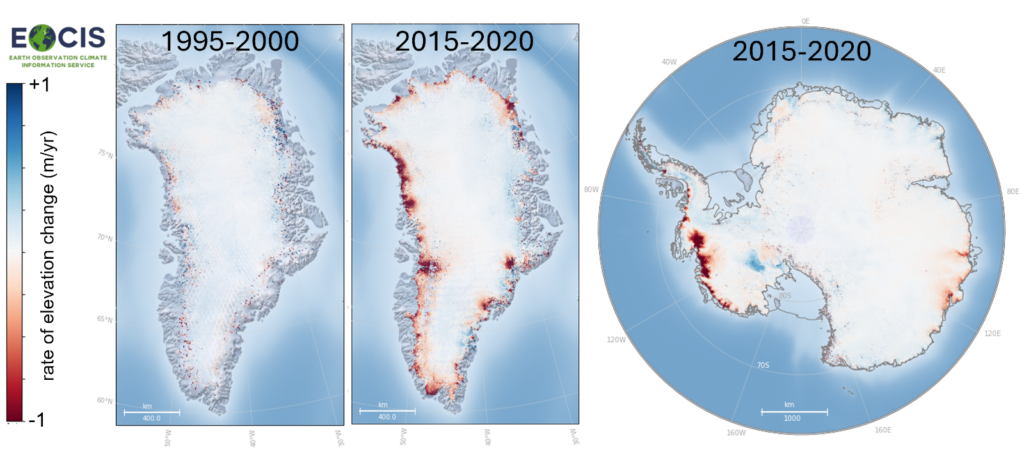
Our satellite record shows us that Greenland’s ice sheet has been losing ice at an increasing rate since the early 2000s, with melting now widespread across the ice sheet. Figure 1 highlights just how dramatic these changes are — comparing rates of ice loss from 1995–2000 to those from 2015–2020 reveals a clear acceleration. Antarctica, however, tells a more complex story. While West Antarctica is experiencing significant ice loss, some areas of East Antarctica have seen minor ice gains. However, these gains are far outweighed by the overall ice loss across the continent. The regional differences remind us that ice sheets are complex systems, and continued satellite monitoring is critical to our understanding of the long-term stability of the ice sheets and assessing its global consequences.
Sea Ice Decline in the Arctic
Arctic sea ice and the snow that blankets it are an important part of our climate system. They act as Earth’s cooling system, reflecting sunlight and regulating ocean temperatures. However, sea ice is diminishing rapidly as the Arctic warms, with significant implications for ocean circulation, ecosystems, and weather patterns far beyond the poles. There’s also a lot of shipping interest in this area as the sea ice has retreated, and while longer melt seasons will open up more shipping routes and increase navigability, this is complicated by some regions now having more complex sea ice formation and drift patterns that are hazardous to shipping.
The EOCIS sea ice dataset provides estimates of sea ice thickness, volume and mass from CryoSat-2, an ESA satellite focused on Cryosphere applications. The sea ice dataset allows us to track both short-term variability and longer-term trends in these essential climate variables. From our detailed record of Arctic sea ice, we see a significant decline in ice thickness and volume since 2010, as can be seen in Figure 2. The satellite’s data reveal a loss of older, thicker, multiyear ice, with thinner seasonal ice becoming more dominant and thus vulnerable to melting. These changes contribute to a warming climate by reducing the Arctic’s ability to reflect sunlight, accelerating further ice loss. Continued monitoring is essential for understanding how changes in sea ice influence wider weather systems and ocean currents.
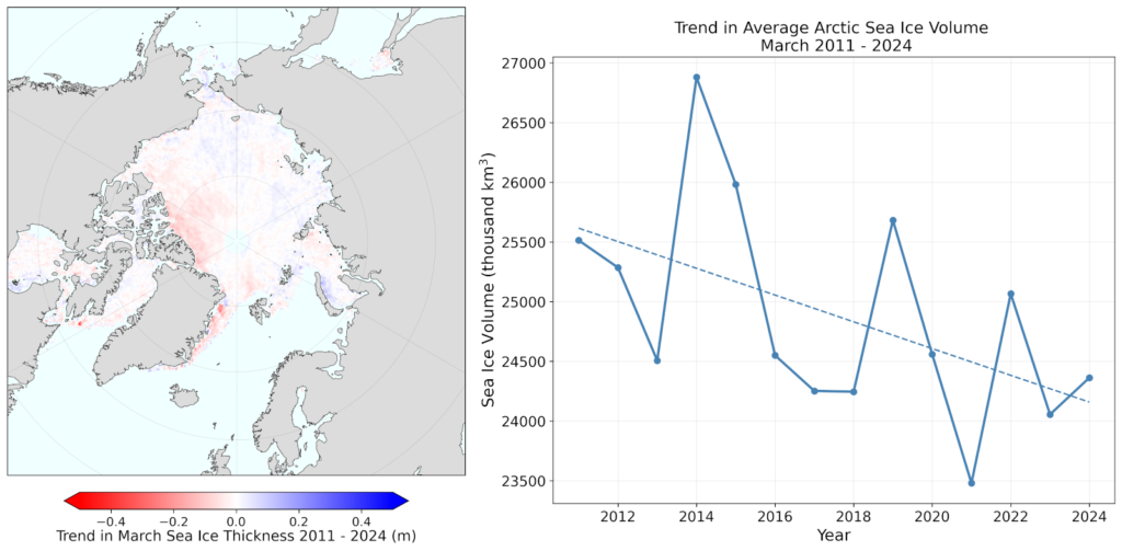
Left: Geographical trends. Right: Timeseries of sea ice volume.
Polar Regions: A Key component to Safeguarding Our Planet’s Future
Ice loss from the ice sheets is currently tracking worst-case scenario projections, meaning decision-makers need to prepare for more extreme sea level rise than previously expected. To better predict future ice sheet contributions to sea level rise, we can combine datasets made from satellites with ice sheet models. By accurately incorporating recent changes observed by satellites into models, we can then run simulations into the future to generate more precise predictions of sea level rise, ensuring that decision-makers have the best possible information to plan for the future.
Similarly, satellite-derived datasets play a crucial role in improving models that predict future sea ice behaviour. As Arctic sea ice continues to decline, these enhanced models help anticipate changes in ice extent and thickness—critical factors impacting on the climate system, as well as being important for stakeholders. By refining sea ice models, we can be better informed about the risks and opportunities in a rapidly changing Arctic.
The insights from both the EOCIS land ice and sea ice datasets provide the scientific foundation necessary for understanding changes to ice in the Arctic and its impact. The challenge posed by polar ice melt is a global one—requiring a global response. By leveraging cutting-edge satellite data and working together, we can make informed decisions to safeguard our planet’s future.