Water Quality Around the Coasts: Insights from Space
By Aquila Erskine, Prof. Steve Groom, Dr. Peter Miller and Dr. Dan Clewley, Plymouth Marine Laboratory…
Coastal waters are some of the most dynamic environments on the planet. Here, rivers meet the sea, freshwater mingles with saltwater, and human activity intersects with natural ecosystems. These areas can be hotspots of biodiversity and centres of economic activity, but they’re also highly sensitive to change.
Monitoring coastal water quality is essential for understanding ecosystem health and managing human impacts. Thanks to satellite technology and initiatives like the UK EO Climate Information Service (EOCIS) and the European Space Agency (ESA) Ocean Colour Climate Change Initiative (OC-CCI), we can now observe these changes on a global scale, every day.
What does ocean colour tell us about water quality?

Satellite images of ocean colour are not just striking – they are scientifically revealing. By analysing subtle variations in ocean reflectance across the visible spectrum, we can find information about what is in the water, like phytoplankton, suspended sediments, and dissolved organic matter. Phytoplankton, for instance, are the foundation of the marine food chain and are vital to the global carbon cycle. They also produce around 50% of the oxygen we breathe, highlighting their importance not just for the ocean but for life on Earth, and we can monitor their abundance from space.
Creating long-term, high-quality datasets from space isn’t straightforward though. There are many different satellites in the sky, with different sensors, calibration methods and resolutions, and a lot of processing goes into getting the data that they collect into an understandable format. This is where EOCIS and the ESA OC-CCI comes in, working to harmonise data from different satellites (including ESA’s Copernicus Sentinel-3 OLCI sensors). EOCIS/OC-CCI works to stitch data records together into easily usable datasets that provide climate scientists with data that meets climate-quality standards. For global observations data are provided at a resolution of 4 or 1 km, appropriate for offshore or oceanic waters but not so good near the coasts.
Resolution, and why it matters in coastal waters
Imagine an algal bloom, sewage spill or oil spill stretching a few hundred meters, that’s quite a long way right? And quite a lot of algae, sewage or oil?
The EOCIS global data are 1km resolution, meaning that each pixel represents a 1km sided square. If an algal bloom or sewage spill or oil spill covers several hundred metres, then this is smaller than a single 1 km pixel and at this scale would go unnoticed.
With Sentinel-3 OLCI’s 300 m resolution, we can detect and monitor coastal waters in finer detail, enabling faster responses to potential threats, like fisheries closures or water quality issues.
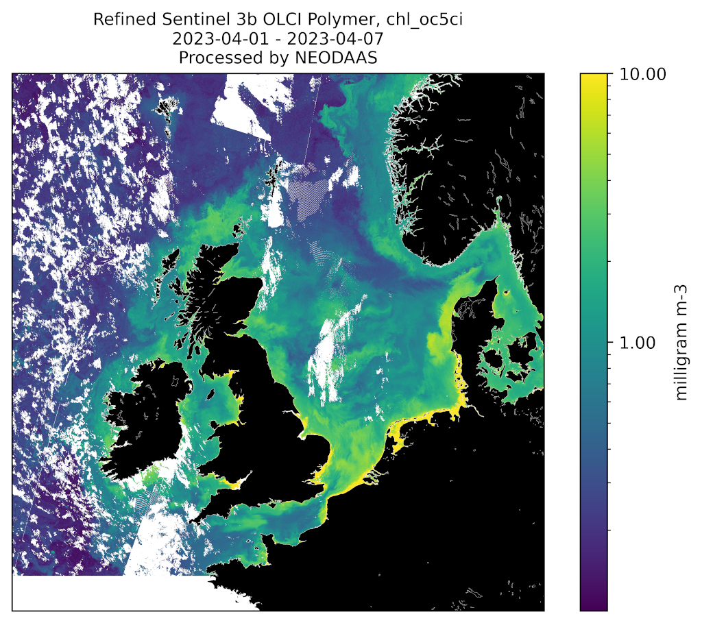
Such higher resolution observations are being developed in the Climate High-resolution UK (CHUK) component of EOCIS. See Fig. 1 which shows the UK over a period 1 – 7 April 2023 where all the clear parts between the clouds have been “stitched” together.
In fact, even higher resolution, down to 10-60m, is also being produced, and data are provided at 100m on the same grid as other CHUK datasets for integration.
Coastal fronts and how they help us understand coastal water quality
Coastal fronts are the boundaries where different types of water meet, similar to a weather front where warm and cold air collide. These areas are super important because they attract lots of marine life, making them key spots for protecting our oceans and planning activities like offshore wind farms, ensuring they don’t harm the environment.
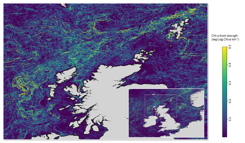
In the past, scientists used sea surface temperature (SST) data to track these fronts, but SST can’t always capture all the details of coastal waters. Now, the EOCIS project has come up with a new method that uses the higher-resolution ocean colour data to find these fronts more accurately. This means researchers can map sharp changes in the water, such as where the concentration of phytoplankton or sediment changes. This is an important advance in the way we use satellite technology, and Fig. 2 shows the level of detail we can capture around the coast, especially for the Scottish lochs and islands.
This new approach gives us valuable information that links the health of coastal ecosystems with the natural processes happening in the water. It’s a big step forward in helping us protect marine life and plan for a more sustainable future. Importantly, the work in EOCIS has enabled further work to be done in an NERC project and another funded by the Crown Estates.

Why is this important?
Coastal waters are the lifeblood of our planet. They provide food, regulate climate, and support livelihoods, yet they are under increasing pressure from human activities and climate change. The EOCIS and OC-CCI projects, through cutting-edge advancements in satellite monitoring, gives us the tools to track these pressures and take meaningful action.
Whether it’s identifying biodiversity hotspots, assessing the impacts of sediment runoff, or guiding the placement of renewable energy infrastructure, the insights provided by EOCIS and OC-CCI ensure that we can make informed decisions to safeguard our coastal and marine ecosystems for generations to come.
Want to know more about Ocean Colour?
For an overview about Ocean Colour, why it matters and how we use it here is a video we made earlier this year as part of Protecting Our Planet Day (POP24), an inspiring live-streamed event organized by STEM Learning UK, ESERO-UK, the European Space Agency, and the UK Space Agency:
Check out our video here: https://youtu.be/fbtOLCaAL60?si=Wrckw8Q_6LOCNuIO
