Can Earth Observation bring confidence to carbon credits?
By Professor Mat Disney and Dr. Cecilia Chavana-Bryant…
Carbon credits have got a bit of a bad reputation in recent years, particularly when it comes to their use in forest carbon offsetting. Carbon credits can be a useful and important part of efforts to reduce emissions and potentially have other benefits in forest creation and protection. But their effectiveness depends on reliable and transparent auditing. Currently, this is a mainly manual and somewhat opaque process, which is ripe for exploitation and gaming.
Within EOCIS, we have been looking at one way to try and improve this process using new observations from ground, air and satellite and focusing on the UK’s Woodland Carbon Code (https://woodlandcarboncode.org.uk/). The WCC is a government-backed quality assurance standard for woodland carbon projects in the UK. It sets out requirements for voluntary woodland creation projects for carbon storage and offsetting as well as other associated benefits including recreation, biodiversity, air quality improvements, reducing water pollution and mitigating flood risks.
Currently, WCC carbon credits (and forest carbon credits more generally) are assessed via field-based measurements. Small sample plots are selected and the trunk diameter and height of the trees within each plot are measured and their species identified. Then, simple empirical (allometric) models are used to translate tree size to mass and then the equivalent sequestered CO2 (eCO2). This process has the huge advantage of being relatively low-cost and low-tech to implement. But it is entirely dependent on the accuracy of manual tree measurements that can be hard to make, as well as on the underpinning allometric models. These models are derived from forestry measurements and are very limited in terms of species, age and environment.

Shocott Park near Bedford, showing field measurement being made on the ground, a map of woodland types from aerial data, and a close-up of individual tree crowns from drone photography.
We know that remote sensing measurements can provide very accurate measurements of tree size and shape, particularly using lidar (see for example https://www.woodlandtrust.org.uk/about-us/what-we-do/research-and-evidence/scatter-project/). Using terrestrial lidar we are able to make very accurate 3D measurements of tree volume and mass, allowing us to effectively ‘weigh’ the trees. We have used this approach previously to show that allometric models tend to underestimate forest carbon in UK woodlands quite dramatically (https://appliedecologistsblog.com/2022/12/20/research-stories-how-to-almost-double-woodland-carbon-overnight/).
For our EOCIS project we are using ground-based lidar at WCC sites to estimate stored carbon, to compare this to the WCC values and to update the allometric models that underpin the WCC estimates. EOCIS colleagues have also been assessing the ability of satellite observations to upscale these plot-based estimates to UK forests more widely. Initial results show that updating the existing allometric models will significantly improve UK woodland carbon estimates.

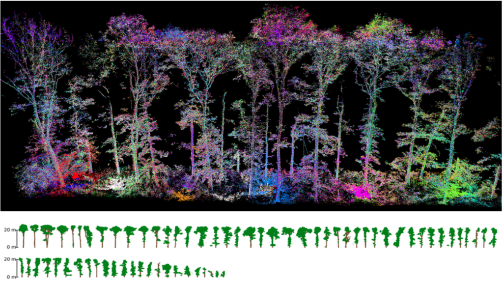
An example of terrestrial lidar data collected in the New Forest (top), with the individual trees extracted from these data shown below. These models allow us to estimate the carbon stored in each tree very accurately.
The benefits of an approach like this is that firstly it allows us to develop more accurate allometric models relating tree size to mass, potentially even for individual projects. Second, the ability to upscale these estimates through UAV, airborne and satellite observations at larger scales allows for much more straightforward reporting and verification across scales. This approach can be applied to many projects very rapidly, providing far more consistent and robust comparisons between projects and over time.
Rebuilding trust in carbon accreditation schemes is hugely important from a climate perspective. Our pilot EOCIS work is already showing promise for helping to achieve this through new observations and methods. We will continue to develop this work with the aim of increasing trust and transparency in this process, leading to greater opportunity for investment.
This was run as an Actionable Information Project (AIP) of EOCIS, which brought together EOCIS contributions from UCL and Southampton University, Woodland Carbon Code, Scottish Forestry, SpaceClipper Industries and the James Hutton Institute.
