“A 4-Hour Early Warning Advantage”: How Europe’s New Geostationary Satellite System is Revolutionizing Wildfire Detection & Monitoring
By Dr. Weidong Xu…

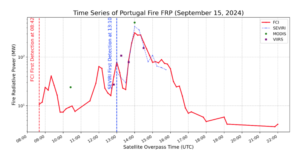
In an impressive showcase of cutting-edge European satellite technology, within which the UK is a key partner, EOCIS scientists have prototyped the EOCIS UK Rapid Fire Alert System – an early wildfire detection and monitoring system based on data from the Flexible Combined Imager (FCI) aboard Europe’s new Meteosat Third Generation Imaging (MTG-I) geostationary satellite. Testing the prototype on the recent severe wildfires in Portugal in advance of next year’s UK fire season, the figure shows that the output from the EOCIS system was able to detect the onset of some of the Portuguese wildfires four hours earlier than its predecessor – Meteosat Second Generation (MSG). By viewing the whole Earth disk every 10 mins, and the UK and Europe every 2.5 mins after launch of the next MTG-I spacecraft, the EOCIS system was also able to identify the development of the new fire well before all of the polar orbiting satellites that are widely used for wildfire detection – two hours before NASA’s MODIS and the Copernicus S3 SLSTR and four hours before NOAA’s VIIRS.
This breakthrough in the early detection of new wildfires marks a significant leap forward in both their rapid identification and their ongoing monitoring, pointing the way to potentially identifying fires before they are reported by the public and so offering the potential to improve emergency response times, reduce wildfire damage and safeguard lives and livelihoods. In heavily fire affected regions, keeping track of the multiple fires starting to burn at the same time, and rapidly identifying the development of additional fires or changes in those being monitored, also aids the agility of the emergency response effort. In the case of the Portugal fires, importantly, when MODIS, VIIRS, and SEVIRI finally detected the example fire shown here, their measurements of fire radiative power (FRP) that relates to the fire’s magnitude and intensity closely matched those of FCI, underscoring the EOCIS prototypes accuracy.

The breakthrough in performance demonstrated in this timeline comes from linking the massive leap in capability provided by MTG-I’s Flexible Combined Imager (FCI) with the continued honing of the highly sensitive fire detection and monitoring algorithms developed over the last decade+ by the EOCIS team – initially for use with the forerunner MSG system. Compared to MSG though, MTG-I provides a far sharper view of the Earth, more frequently and in more individual spectral bands of light. This includes measurements in the middle infrared, shortwave infrared and thermal infrared bands, each of which are differentially sensitive to sub-pixel fires and together enable the detection of fires covering less than 0.1% of the pixel area – so down to perhaps 100 m² under good observation conditions. This is an order of magnitude smaller than the minimum detection size with MSG – which is the key to early identification. The entirety of the UK and continental Europe can be scanned every 10 minutes for such fires, and every 2.5 minutes after the launch of the next MTG-I in a year or two.

Smoke from the Portuguese wildfire whose development is detailed in the graph – seen here at 14:00 UTC on 15 Sep 2024. MTG FCI true color composite image.

Another fire identified by MTG FCI – this time close to Athens at 16:00 UTC on 11 Aug 2024. MTG FCI true color composite image.
Early fire detection can help fundamentally transform wildfire response and management. For communities in fire-prone regions like Portugal and Greence, these extra hours of warning time may help transform fire response capabilities by enabling firefighters to respond while fires are in their earlier, smaller and less intense initial stages. Communities could then gain precious time to implement evacuation plans in a more coordinated, safe and systematic manner, whilst emergency response teams might be able to deploy their resources more efficiently and effectively guided by more accurate and more timely information. The earlier the warning of new fire starts is provided, the better the chance of both property and ecosystems being protected from potentially devastating wildfire damage.
Toward a Safer Future
Climate changes in some regions possibly increases the frequency and intensity of severe wildfires. Innovative satellite technologies like MTG and its FCI sensor are poised to play an increasing role in helping mitigate some of the worst impacts of wildfire activity. For vulnerable communities, the ability to act hours earlier could mean the difference between a minor incident and a devastating catastrophe. Furthermore, early detection not only means the chance of lessening the potentially damaging fire impacts on the ground – it also means that the amount of polluting smoke the fire release might be lower and thus the air quality and health impacts from the smoke could be significantly lessened. These impacts are now recognised as severe, with hundreds of thousands of people around the world dying early each year because they are exposed to landscape fire smoke.
Whilst MTG-FCI has already shown its benefits to be considerable for this application, the EOCIS systems capabilities are set to become even more impressive in the near future – with the planned launch of a second MTG-I satellite in 2026 and a reduction in the scanning time to just 2.5 minutes. This enhancement will make the system even more effective at catching fires in their earliest stages, further improving the timeliness and detail of the information available to help prevent potentially catastrophic wildfire spread and potential the release of massive amounts of polluting smoke.
Why This Matters to the UK
In the UK, wildfires threaten our forests and peatlands, which store more carbon than the combined forests of Britain, France and Germany. Fires can spread into urban areas as well, as they did in 2022 when dozens of fires burned in London’s green spaces during that summer’s heatwave, destroying many homes. Currently, UK Fire and Rescue Services attend tens of thousands of wildfire incidents each year, and the Met Office predict the potential for significant increases in fire activity due to warmer, drier summers. EOCIS’ UK Rapid Fire Alert System, based processing of the data coming from FCI onboard the new MTG-I satellite, will be a powerful tool in the fight to help manage wildfires and protect both our ecosystems and our communities.
